 |
| The author at Bumla Pass in November 2012. Photo Credit: Vijainder K Thakur |
Bum La Pass, on the Line of Actual Control (LAC) between India and China, is about three hour, but just 35 km drive from Tawang over a very rough road.
The area is under Army control; to visit it, you need to get a pass from the DC's office in Tawang, and have it stamped at the Brigade Major's office opposite Tawang War Memorial after 5 PM.
 | |
| The road from Tawang to Bum La Pass. Photo Credit: Google Maps |
The Journey
The road from Tawang to Bum La Pass starts with a steep climb upto the ridge line and then goes past some very scenic lakes. |
| Heart Lake, Tawang District. Photo Credit: Vijainder K Thakur. |
Heart Lake: Located at 13,000 ft this heart shaped lake is on top of the first ridge line.
P.T. Tso (Lake): Located at 13,300 ft, 13 km from Tawang, the lake has a built up pedestrian pathway going around it with five shelters to sit and enjoy the scenery. You can rent camping tents for an overnight stay. The lake is managed by the state, not the military.
 |
| P.T. Tso (Lake): Located at 13,300 ft and 13 km from Tawang, the lake has a built up pedestrian pathway going around it with five shelters to sit and enjoy the scenery. You can rent camping tents for an overnight stay! Photo Credit: Vijainder K Thakur. |
P.T. Tso (Lake): Located at 13,300 ft and 13 km from Tawang, the lake has a built up pedestrian pathway going around it with five shelters to sit and enjoy the scenery. You can rent camping tents for an overnight stay!
 |
| Nagu La Lake is about 4 km ahead of P.T. Tso at 13,360 ft. Photo Credit: Vijainder K Thakur. |
 |
| Unidentified Lake on the route. Photo Credit: Vijainder K Thakur |
 |
| Another unidentified lake short of Bumla Pass. Photo Credit: Vijainder K Thakur |
Three kms ahead of Nagu La is a Y-Junction with one road leading to Sangetsar Lake and the other to Bum La pass.
Klemta, 8 km short of Bum La, serves as the base camp for the army posts along the border.
Bum La Pass & It's Military Significance
Bum La pass (LatLong: 27.72122,91.822701) is at 15,200 ft. A Stop sign marks the LAC (Top photo) which is U shaped in the sector..
 |
| Bumla Pass. Photo Credit: Vijainder K Thakur |
No awards for guessing the name of the Shivling shaped peak on the left in the photo at the top. Yes, it's Shivling Peak! And it marks the northern extent of the LAC on the left looking towards China (West). Similarly, the LAC extends north on the right (East) along a ridge line.
Tawang is the focal point of the Chinese claim on Arunachal Pradesh, yet Bum La pass is one of the most peaceful sectors along the LAC.
Around 130 km to the East of Bum La Pass along the LAC, the PLA and the Indian Army are in an eyeball to eyeball confrontation with the fingers always resting on the triggers of loaded automatics.
The Indian Army is positioned right on the LAC in this sector manning positions in terrain and weather that are treacherous.
The Chinese side of the LAC is manned by border guards, not PLA regulars. The Chinese border guards live more comfortably than Indian Army personnel, in camps that are well recessed from the LAC in less hostile terrain and linked to Tibetean heartland with metalled highways.
Though the PLA doesn't man the LAC, but monitors it continuously. A PLA radar and electronic monitoring post enclosed in a white radome is visible slightly to the right of my shoulder.
 |
| A Chinese radar and electronics eves dropping unit across the LAC at Bum La pass. Photo Copyright ©: Vijainder K Thakur |
The Indian Army maintains vigil against intrusions through optical sensors.
A heap of stones on the Bum La pass crossing symbolizes Indian - Chinese friendship and visitors to the LAC add a stone to the heap in symbolic support of India - China friendship.
Also there is a rock with a signboard that says - Rock of Peace, and the flags of the two nations.
 |
| India - China Friendship heap of stones and rock. Photo Copyright ©: Vijainder K Thakur |
Army personnel positioned at the Bum La Pass border check point readily brief visitors on the pass.
The Indian Army is very supportive of visitors and extends the same warmth to them as it does to the people of Arunachal Pradesh.
The people of Arunachal Pradesh admire the Indian Army and celebrate Indian Republic & Independence days with more fervor than perhaps any other state. The Army is proud of the support that it enjoys with the people of the state.
You could say the Indian Army's rapport with the people of Arunachal Prades is as much a deterrent to Chinese military adventure as the Indian Army's strength.
Indian Army - PLA Conference hall at Bum La Pass, Tawang District, Arunachal Pradesh
This is where delegations from the Indian Army and PLA meet twice a year to maintain peace on the border.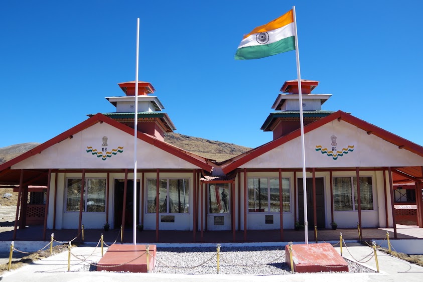 |
| Conference and banquet hall for PLA and Indian Army brass at Bum La pass. Photo Copyright ©: Vijainder K Thakur |
On the left is the conference hall, and on the right is the banquet area.
The Chinese side hosts Border Personnel Meetings (BPMs) in February and June, and the Indian side on August 15 and October 20.
Of the four meetings, two are formal with an agenda and the remaining two celebratory to mark the Chinese Spring Festival and India's Independence Day.
PLA personnel bring traditional Chinese hats and nuts to the conference as gifts for Indian soldiers, and covet liquor and cigarettes in return. Old Monk is the sought after liquor. The Indian Army obliges.
No comments:
Post a Comment